Keeping an Eye on
the Storm - Hurricane Guide
Hurricane season runs from June 1 through November 30. Be prepared!
WHAT IS A HURRICANE?
The name hurricane is derived from the Caribbean God of Evil, Hurricane. The unpredictable behavior of high seas, and strong winds have been man's nemesis for centuries. Ingredients for a hurricane include a pre-existing weather disturbance, warm tropical oceans, moisture, and relatively light winds, aloft. If these conditions persist long enough, they can combine to produce the violent winds, incredible waves, torrential rains, and floods associated with hurricanes. Each year, an average of 10 tropical storms develop over the Atlantic Ocean, Caribbean Sea, and Gulf of Mexico.
HOW STRONG WILL THIS HURRICANE SEASON BE?
Some meteorologists believe that a twenty-plus-year-cycle of unusually strong hurricanes started in 2004. The Atlantic hurricane season that runs from June 1 through November 30 - and peaks from August through October - will be active, but it shouldn't be as destructive as 2005's record-setting season, according to the May 31 forecast of the highly esteemed William Gray - the "guru" of hurricane forecasting - and his team of researchers with Colorado State University's Tropical Meteorology Project.
HURRICANES, or TROPICAL CYCLONES - Low-Pressure Systems over Tropical Waters:
A hurricane is a type of tropical CYCLONE, the general term for all low pressure systems over tropical waters. The cyclone is accompanied by thunderstorms and (in the northern hemisphere) a counter-clockwise circulation of winds near the earth's surface. Tropical cyclones are classified as follows: A TROPICAL DEPRESSION is an organized system of clouds and thunderstorms with a defined circulation and maximum sustained winds of 38 mph (33 knots) or less. A TROPICAL STORM is an organized system of strong thunderstorms with a defined circulation and maximum sustained winds of 39 to 73 mph (34-63 knots). A cyclone is given a NAME when the winds from these storms reach 39 mph (34 knots). A HURRICANE is an intense tropical weather system of strong thunderstorms with a well-defined circulation and maximun sustained wind of 74 mph (64 knots) or higher. SUSTAINED WINDS are defined as a 1-minute average wind, measured at about 33 ft. (10 meters) above the surface. 1 knot (abbreviated as kt.) equals 1 nautical mile per hour, or 1.15 statute miles per hour.
STORM CATEGORIES
Hurricanes are categorized according to the strength of their winds, using the Saffir-Simpson Hurricane Scale; a Category 1 Storm has the lowest wind speeds, while a Category 5 Hurricane has the strongest: Tropical Storm (winds 39-73 mph). Category 1 Hurricane (winds 74-95 mph) - no major damage to buildings; damage to unanchored mobile homes and poorly constructed signs; some coastal flooding and minor pier damage. Category 2 Hurricane (winds 96-110 mph) - some damage to building roofs, doors and windows; considerable damage to mobile homes; flooding damage to piers; small watercraft in unprotected moorings may break their moorings; some trees will be blown down. Category 3 Hurricane (winds 111-130 mph) - some structural damage to small residences and utility buildings; large trees will be blown down; mobile homes and poorly-built signs are destroyed; flooding near the coast will destroy smaller structures and larger structures can be damaged by floating debris; terrain may be flooded well inland. Last year's destructive Katrina was only a category 3 hurricane when it made landfall. Category 4 Hurricane (winds 131-155 mph) - more extensive curtainwall failures with some complete roof structure damage on small residences; major erosion of beach areas; terrain may be flooded well inland. Category 5 Hurricane (winds 156 mph and greater) - complete roof destruction on many residences and industrial buildings; some complete building destruction with small utility buildings blown over or blown away; flooding will cause major damage to the lower floors of all structures near the shoreline; a massive evacuation of residential areas may be required.
WHAT MAKES UP A HURRICANE?
A well-developed hurricane consists of an eye, an eyewall, and spiral bands of showers and thunderstorms. In the eye, winds are relatively calm and there is a gentle sinking motion in the atmosphere which leads to mostly clear skies. Surrounding the eye is the eyewall, which contains the most violent winds and the most intense showers and thunderstorms in the hurricane. The eyewall can contain tornadoes, and the winds in the eyewall have the greatest potential for causing a deadly storm surge. Outside the eyewall, spiral bands of showers and thunderstorms rotate around the storm. These bands of showers and thunderstorms can also be very intense; they can move into an area very rapidly, and are the most likely area in the hurricane for a tornado to form. Hurricanes and tropical storms bring with them 4 main threats: high winds, coastal storm surge, inland fresh water flooding, and tornadoes.
WHAT IS A HURRICANE WATCH? WHAT IS A HURRICANE WARNING?
A hurricane WATCH means that hurricane conditions are POSSIBLE in the area of the watch, usually within 36 hours, while a hurricane WARNING means that hurricane conditions are EXPECTED in the warning area, usually within 24 hours.
HURRICANE NAMES
During World War II, women's names were first used to name tropical storms and hurricanes (with some variations in practice in the early 1950's). The first named Atlantic Basin hurricane was Able, in 1950. From 1953 to 1979, the U.S. Weather Bureau began used a standardized list of exclusively female names in naming tropical storms and hurricanes in the Atlantic Ocean and the Gulf of Mexico - the "Atlantic Basin." In 1979, alternating male and female names were included in lists for hurricanes in the Atlantic Basin. The hurricane name lists are agreed upon at international meetings of the World Meteorological Organization. Thenames have an international flavor, because hurricanes affect other nations and are tracked by the public and weather services of many countries. There are currently 6 lists of names used in naming hurricanes - a different list is used each year, and the lists are repeated in 6-year cycles. The letters Q, U, X, Y, and Z are not used in the list, due to the scarcity of names beginning with those letters. Names associated with storms that have caused significant death and/or damage are usually retired from the list and a replacement name is selected.
HOW TO TRACK A HURRICANE
Tropical storm advisories describe the present position, the forecast position, and the intensity of the storm, and each advisory is numbered consecutively for each storm. Tropical cyclone advisories are issued at 6-hour intervals - at 12:00 a.m. midnight, 6 a.m., 12:00 p.m. noon and 6 p.m., Eastern Daylight Time (EDT). Bulletins in-between the scheduled times provide additional information. Each message gives the name, eye position, intensity, and forecasted movement of the tropical cyclone. Hurricane eye positions are given by latitude and longitude to the nearest one-tenth of one degree. When the storm moves within radar range, eye position may also be given as statute miles and compass direction from a specified point. When you receive an advisory, mark the eye position on the tracking chart. Because hurricanes change direction very quickly, you should concentrate more on where the storm will go rather than where it has been.
HOTLINE FOR INFORMATION ABOUT A STORM
For those in Florida, a toll-free hotline - the Florida Emergency Information Line (FEIL) at 1-800-342-3557, is activated by the Department of Community Affairs, a Division of Emergency Management, at the time of an emergency, to provide accurate, up-to-date information, or you can log-on to the website, www.FloridaDisaster.org Information will be given on the following topics: preparation before, during and after a hurricane; road closures and alternate routes, available/open shelters in host or impacted counties, shelters designed for special-needs patients; hotels and motels that accept pets, instructions for boaters on moving watercraft to safer ground; and re-entry information, once it is safe to return to the affected area.
PREPARE FOR THE STORM - SAFETY & CONVENIENCE TIPS
If your area is threatened by a major storm, use these TIPS in preparation:
* Withdraw emergency cash; teller machines won't work if the power is off.
* Turn off electricity and gas; unplug electronic equipment.
* Keep insurance policies, valuables, cash and credit cards in a safe, handy location, wrapped in a waterproof container or plastic bag.
* Plan escape routes in advance.
* Have a family plan - each family member should know what to do and where/how to contact/meet other family members.
* Have food, water, batteries, and emergency tools and supplies ready.
* Monitor the latest advisories.
* Leave low-lying areas and mobile homes.
* Board windows or protect them with shutters or tape.
* Secure outdoor areas - loose items can become missiles in strong winds. This is a MAJOR cause of property damage and personal injury.
* Make arrangements for pets - shelters do not provide for the needs of pets - many shelters will not accept pets.
* Keep cars fueled; gas pumps won't work if electricity is off.
* Turn refrigerator/freezer to coldest settings. If power is off, keep doors closed.
* Pools - Don't drain your pool; drop the water level by 1 or 2 feet. Place outdoor furniture and pool equipment into the pool, and turn off the electricity to the pool pump. Add extra chlorine to compensate for heavy rains.
WHEN A WARNING IS ISSUED
When a hurricane warning is issued, the leading edge of the storm is just hours away. Complete all preparations as soon as possible, and move your supplies and survival kit (see below) to your safe room (see below); close all interior doors; secure and brace external doors, especially double doors that open inward and garage doors. Stay inside.
SURVIVAL KIT - BE PREPARED
Your SURVIVAL KIT should include: drinking water (at least 5 gallons per person); buckets of water for flushing toilets and containers that can be used as emergency toilets (2 or more 5-gallon buckets with covers, lined with heavy-duty trash bags); unscented liquid bleach; water purification tablets; non perishable (canned or packaged) food and beverages (to last for several days); pet carrier(s), food and water for pets; a non-electric can opener; emergency camping-type cooking equipment and fuel/fire extinguisher; portable cooler; matches or lighters; rope; duct tape; a tarpaulin ("tarp"); baby food, diapers and formula; extra prescription medicine (2-week supply); battery-powered radio and extra batteries; 2 flashlights and 2 extra packets of batteries; a list of important phone numbers, insurance policies and titles to property (etc). and other valuables; toiletries; special dietary needs; insect repellant; first-aid kit; and cash.
Water service could be disrupted - freeze water in plastic jugs and fill up water containers such as bathtubs, jugs, bottles, cooking utensils and other containers, after first cleaning with unscented liquid chlorine bleach, rinsing with water and allowing to dry. Washing machines can also be filled with water for emergency use.
IF POWER IS INTERRUPTED
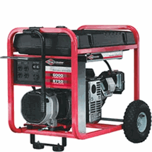
DO NOT use a generator indoors, in a garage, or in an enclosed or partially-enclosed area. Areas where generators are being used MUST be well-ventilated. Carbon monoxide poisening from generators is a major cause of hurricane-related deaths.
SAFE ROOM
If you are not required to evacuate, and you cannot protect all your windows and doors, choose a SAFE ROOM, a room in the center of your home, or a room with small or few windows. If you live in a 2-story house, go to an interior first-floor room, such as a bathroom, a closet, or under a staircase. If you live in a multiple-story building, go to the first or second floor and take refuge in a hallway or an interior room such a closet that is away from windows. Interior stairwells and areas around elevator shafts are generally the strongest parts of a building. If your selected room has windows, you must have some form of window protection. Move your water and food supply to your safe room, along with a battery-operated radio, flashlight(s) and important documents and valuables. Go to your safe room when outside conditions worsen or when you hear a hurricane warning issued. Do not leave the safe room until the "all clear" is issued on the radio. Don't be fooled by the calm eye of the storm into going outside and placing yourself in peril - this is a time when many are injured or killed (by going outside too soon).
EVACUATION
An EVACUATION order is received from local government officials, and relayed over local radio and television stations. Once issued, an evacuation order is mandatory under Florida law. When an evacuation order is issued, you have about 8 hours to clear your yard of loose objects such as hoses, flowers pots, garbage cans, water hoses, birdhouses, birdbaths, windchimes, burn barrels, barbeque grills and lawn chairs (ANY loose object in your yard). Secure these items, inside, or securely tie them down; move valuables and electrical equipment away from windows, and cover them with plastic bags or place them in a cabinet, large appliance or closet. Call friends/relatives and let them know your evacuation destination; secure all windows and doors tightly; load your survival kit; and turn off electricity, water and gas. Be sure to take your pets with you, secure them inside your home, or take them to a safe location with proper food, water and a carrier. Evacuate quickly, but safely.
If you live in a manufactured home or in an evacuation area, the best option is to make arrangements to stay in a non-evacuation area - with a friend, relative, co-worker, or possibly at your place of employment. Your LAST option should be a public shelter, because space is limited and conditions are austere. If you evacuate to a public shelter, be prepared for very crowded conditions, and bring folding chairs, cots, pillows and blankets, special dietary needs items, prescription medications, and items such as baby diapers, and formula, (for example), along with books, puzzles and other quiet games for entertainment. DO NOT bring firearms, illegal drugs or alcohol. Bring pets only to shelters that allow pets. Learn where these shelters are, in advance, and bring supplies and food and water for your pets, including a leash and a carrier.
EMERGENCY SHELTERS
CITRUS COUNTY SHELTERS - Through the hurricane season, Citrus County officials will open shelters as needed. Residents should monitor news reports for changes, or contact the emergency management office at (352) 726-4488, extensions 356 or 210, or check the website, www.bocc.citrus.fl.us/disaster/disaster.jsp Designated shelter sites are: CITRUS SPRINGS: Citrus Springs Elementary School, 3570 West Century Blvd. & Citrus Springs Middle School, 150 W. Citrus Springs Blvd.; CRYSTAL RIVER : Rock Crusher Elementary School, 814 S. Rock Crusher Rd.; FLORAL CITY: Floral City Elementary School, 8457 E. Marvin St.; HERNANDO: Forest Ridge Elementary School, 2927 N. Forest Ridge Blvd. & Hernando Elementary School, 2353 N. Croft Ave.; INVERNESS: Citrus High School, 600 W. Highland Blvd.; Inverness Elementary School, 206 S. Line Ave.; Inverness Middle School, 1950 U.S. 41; Pleasant Grove Elementary School, 630 Pleasant Grove Rd. & Withlacoochee Technical Institute, 1201 W. Main St.; LECANTO: Lecanto School Complex, 3810 W. Educational Path.
LEVY COUNTY SHELTERS
Through the hurricane season, Levy County officials will open shelters as the need requires. Residents should monitor news reports for changes, or contact the emergency management office at (352) 486-5100, 486-5155 or 486-5576, or contact their website, www.levydisaster.com PRIMARY Shelters are: Bronson Elementary School (special needs - capacity 800), State Road 24, BRONSON; Chiefland Elementary School (capacity 820), 1205 N.W. 4th Ave., CHIEFLAND; and Williston Elementary School (capacity 775) 801 S. Main St., WILLISTON. SECONDARY shelters are: BRONSON: Bronson Middle/High School, 1 Eagle Dr.; CEDAR KEY: Cedar Key School, 951 Whiddon Ave.; CHIEFLAND: Chiefland Middle School, 811 N.W. 4th Dr. & Concord Baptist Church, County Road 336; INGLIS: Inglis Community Center, 135 W. Highway 40; OTTER CREEK: Otter Creek Baptist Church, 171 S.W. 3rd St.; & Otter Creek Fire Department, 555 S.W. 2nd Ave.; ROSEWOOD: Rosewood Baptist Church, Highway 24 & Rosewood Community Center; WILLISTON: Joyce Bullock Elementary School, 130 S.W. 3rd Street; Williston Middle School, 20550 N.E. 42nd Place & First Baptist Church of Williston, 339 E Noble Ave.; YANKEETOWN: Yankeetown School, 4500 W. Highway 40.
MARION COUNTY SHELTERS
Through the hurricane season, Marion County officials will open shelters as the need requires. Residents should monitor news reports for changes, or contact the emergency management office at (352) 622-3205, or visit their website, www.marioncountyfl.org/Disaster/DP_Home.htm Designated shelter sites are: BELLEVIEW: Belleview High School, 10400 S.E. 36th Ave. (special needs) & Belleview Middle School, 10500 S.E. 36 Ave.; CITRA: North Marion High School, 151 W. Highway 329; DUNNELLON: Dunnellon High School, 10055 S.W. 180 Ave.; FORT McCOY: Ft. McCoy School, 16160 N.E. Highway 315; OCALA: Lake Weir High School, 10351 S.E. Maricamp Rd.; Madison Street School, 401 N.W. Martin L. King Ave. (special needs & general population); Saddlewood Elementary School, 3700 S.W. 43 Court; Vanguard High School, 7 N.W. 28 St. (will take pets); West Port High School, 3733 S.W. 80th Ave. (special needs & general population); SILVER SPRINGS: East Marion Elementary School, 14550 N.E. 14 St.
AFTER THE STORM
After the storm, continue listening to local TV/radio stations, or the National Oceanic and Atmospheric Administration (NOAA) Weather Radio station at a frequency of 162.550 MHz, for instructions. BE CAREFUL - THIS IS A TIME WHEN MANY INJURIES AND DEATHS WILL OCCUR, commonly due to carbon monoxide poisening from generators being used without proper ventilation, from injuries received while cleaning-up debris, and/or by coming in contact with downed power lines.
* If you have evacuated, return home only when local officials tell you it is safe to do so.
* Inspect your home for damage.
* For safety reasons, use flashlights in the dark rather than candles.
* Leave your safe room slowly and carefully. Inspect damage, INSIDE your house only, and begin cleaning up the most dangerous indoor conditions, such as broken glass.
* Wait for the "all clear" from local authorities before you go outside, drive, or return home. Emergency vehicles have priority use of roadways.
* When venturing outside, avoid downed or dangling utility wires. Be especially careful when cutting or clearing fallen trees or walking through water puddles - they may have power lines tangled or lying in them.
DISASTER ASSISTANCE
Assistance is available, for individuals and businesses needing assistance, after a Presidential disaster declaration. The first step is to call the Federal Emergency Mananagement Agency's (FEMA's) National Tele-Registration Center at 1-800-621-3362 or 1-800-462-7585 (TTY). Once an application is submitted, further assistance will be coordinated through a Disaster Recovery Center which will be established in each of the declared counties or regions.
BE SAFE - BE PREPARED - HAVE A PLAN...
Disaster Preparation - Don't forget your pets...
Now that hurricane season is upon us, pet owners should review their family's hurricane preparedness plan to ensure it includes their pets.
If you evacuate your home, DO NOT LEAVE YOUR PETS BEHlND, because even if they survive the storm, they could escape through broken doors or windows and become lost - and subject to a very dangerous environment. A familiar neighborhood could look very different after a storm, causing your pet to become disoriented.
Evacuating is stressful for animals too, so take precautions to reduce the stress for them.
Make sure you transport your pet in a secure pet carrier, so that if he panics, he cannot escape, and you should place a couple favorite toys and security items in your pet's carrier.
Your pet should have a current rabies vaccination and be micro-chipped, with tags proving this a tag on his collar, along with a tag that has your name and telephone number, all securely fastened to his collar. Your veterinarian should have the micro chip information, and most importantly, the micro chip should be registered with the company that provided the micro chip, in the event that your pet becomes lost at a distance from his home. These tags would be your pet's "ticket back home" if he should become lost. If you evacuate and leave your pet with a friend or at a kennel, leave the address where you'll be along with a phone number where you can be
reach with the friend or at the kennel; also place this information on your pet's carrier.
Most public evacuation shelters offer only the most basic accommodations for people and DO NOT accept pets. If you need to evacuate, find out which shelters and motels close to home are pet-friendly, and arrange to stay there, or else contact friends and relatives who are willing to share their homes with you and your pets.
At the start of hurricane season, it would be wise for you to arrange for your pet's boarding at a veterinary clinic, if you have no other options for a safe place for your pet to stay, in the event that a storm could necessitate your evacuating, as there is a limited amount of space available and many more pets to be boarded than room for pets that need to be boarded.
Your "Pet Survival Kit" should include documentation that proves you own your pet, a current rabies certificate (applies to dogs, cats, and ferrets) and a picture of your pet, to prove that he is your pet should you and your pet become separated. Other items should include pet food, bottled water, a pet cage or kennel, a strong leash, any medications your pet takes, your veterinary records, your pet's current rabies certificate, a first aid kit, food dishes, your pet's favorite toys, a hand-operated can opener, pet waste bags for dogs, or litter items for cats, including a litter box, litter, a scooper and waste disposal bags.
Animal Control Services: Inglis & Yankeetown - (352) 447-0303; Levy County - (352) 486-5138; Citrus County - (352) 726-7660; and Marion County - (352) 671-8727.
Home|Events|Classifieds|Sheriff's|Veterans|Election|
Links|Fishing|Subscribe|Contact
Us|